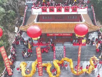
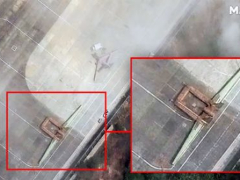
China's launch of satellites with high spatial resolution is of great significance.
I. Significance of high spatial resolution satellites
1. Enhanced Earth Observation Capabilities
High spatial resolution satellites can capture more detailed images of the Earth's surface. For example, they can clearly distinguish small scale geographical features such as individual buildings, small land parcels, and fine scale vegetation patterns. This is crucial for applications in urban planning. In urban areas, planners can use these high resolution images to accurately assess the layout of existing buildings, plan new infrastructure projects like roads and bridges more precisely, and manage urban expansion in a more scientific way.
2. Disaster Monitoring and Management
In the event of natural disasters such as earthquakes, floods, and forest fires, these satellites can provide timely and detailed information. For a flood disaster, they can identify which areas are inundated at a very detailed level, including the extent of flooding in small villages or along riverbanks. This information helps disaster relief teams to quickly allocate resources, plan rescue operations, and assess the damage more accurately for post disaster reconstruction.
3. Agricultural Applications
Farmers and agricultural researchers can benefit from the high resolution satellite imagery. They can monitor the growth status of crops at a very fine scale. For instance, it is possible to detect early signs of crop diseases or nutrient deficiencies in individual fields. This enables timely intervention, such as targeted spraying of pesticides or fertilizers, which can improve agricultural productivity and reduce losses.
4. Environmental Protection
High resolution satellites can closely monitor environmental changes. For example, they can detect illegal logging activities in forests by identifying small scale clear cut areas. In the field of marine protection, they can observe the distribution and changes of coastal ecosystems, such as coral reefs and mangroves, at a detailed level, which is essential for formulating effective environmental protection strategies.
II. Technological and Research Achievements
1. Optical Imaging Technology
These satellites are often equipped with advanced optical imaging systems. The development of high quality lenses, detectors, and image processing algorithms allows them to achieve high spatial resolution imaging. The lenses need to have high precision manufacturing technology to ensure accurate focusing and minimal distortion. The detectors must have high sensitivity to capture weak light signals and convert them into digital images accurately.
2. Satellite Platform Technology
Stable satellite platforms are required to ensure the accuracy of imaging. Technologies related to satellite attitude control, orbit determination, and thermal control are crucial. Precise attitude control systems can keep the satellite in the correct orientation during imaging to avoid blurring of images. Orbit determination technology ensures that the satellite can cover the target area as planned, and thermal control technology protects the satellite's on board instruments from extreme temperature changes in space, ensuring their normal operation.
3. Data Transmission and Processing
High resolution satellite data has a large volume. Therefore, advanced data transmission technologies are needed to ensure that the data can be transmitted back to the ground in a timely manner. On the ground, powerful data processing systems are required to handle and analyze these large volume data. Big data processing techniques, including parallel computing and data compression algorithms, are used to extract useful information from the massive satellite data quickly.
|
|
 |手机版|标签|新闻移动网xml|新闻移动网txt|全球新闻资讯汇聚于 - 新闻移动网
( 粤ICP备2024355322号-1|
|手机版|标签|新闻移动网xml|新闻移动网txt|全球新闻资讯汇聚于 - 新闻移动网
( 粤ICP备2024355322号-1|